 We all know you can watch your speed, check the gradient and so on with your Garmin. But how much else can you do? Michael Hanslip discusses how you can really get the most from one of these gadgets.
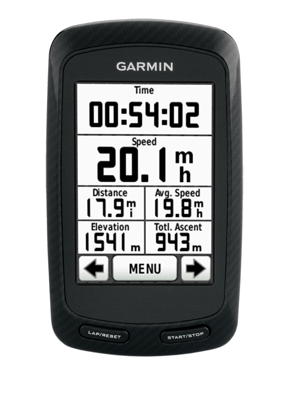
These days it seems to be de rigueur to have a Garmin GPS computer on your bike. For the uninitiated, all of the Garmin models take traditional bike computer functions like speed and distance and throw in the ability to record a trail of exactly where you went and how fast you were going at each point. From the comfort of your home PC you can then upload the fine details of your ride for a variety of uses (more on this later!).
For the past weeks I have been putting a Garmin 800 through its paces in order to help you get the most out of this very powerful tool. My kit included two mounts, a speed and cadence unit, a soft heart rate strap and a chip containing the street directory of Australia and New Zealand. The unit actually works fine without any of the accessories (including the mount as it will function perfectly well in a jersey pocket or backpack as long as it has a clear ‘view’ of the sky) but I advise you to consider using them all.
The mount is clever in that it works on both bars and stems and the included plethora of stretchy rings that hold it on means it will fit on most any diameter piece you might like to put it on. The speed sensor duplicates the functions of the GPS reception, except that the speed unit works in tunnels, on trainers when you aren’t actually moving and on tight bends (particularly noticeable for forest singletrack and velodromes) where the GPS sampling rate ‘misses’ some of your motion by clipping the corners. The map on a chip is necessary if you want to use the 800 like a car navigation system and have it direct you along a route you are unfamiliar with. It is worth noting that while the 800 will help you to navigate, the 200 and 500 models are not navigation aids.
Like all navigation instruments (for boating, automotive or hiking uses) the 800 requires some familiarisation with how it plans routes. If you just plug in your destination and tell it to take you there, it will succeed – but often it causes a double-take on the exact route selected. Use the device to navigate to known destinations before you rely on it to get you to an unknown one.
Before you scoff at the idea of needing navigation on your bike, consider there are several cases where it might be useful:
- You use your bike as your transport and you are going somewhere you haven’t been before;
- You are participating in a long ride where fatigue, excitement or just unfamiliarity with the route means you might miss a crucial turn;
- You are trying to follow someone else’s directions – if they can provide GPS derived instructions it becomes a trivial exercise.
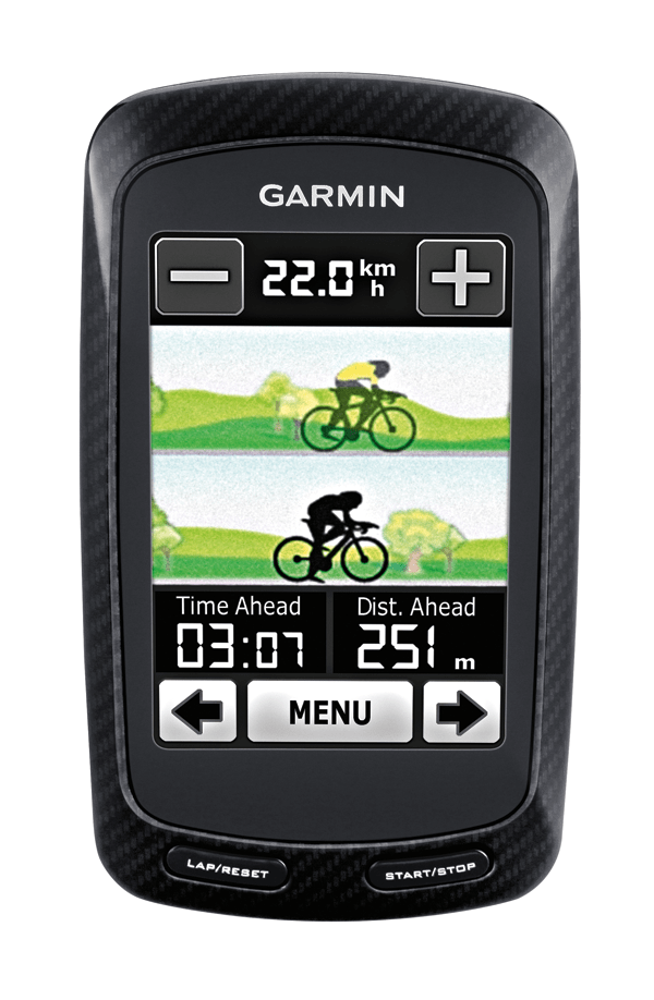
- My favourite is trying to outperform a previous attempt (yours or someone else’s) at a particular route. The Garmin will ensure you stay on course whilst telling you how far ahead (or behind) you are on this occasion.
I mentioned that my review Garmin came with a set of maps on a memory card. The basic 800 knows where you are in space (latitude and longitude) but it has no in-built notion of where anything else is. To navigate turn-by-turn you need a street map to plot your location onto. The Garmin maps are certainly the easy option, but are by no means the only option. While it would be an article in itself describing all the ways to do this, it is quite easy to download open-source maps (including singletrack trails for you mountain bikers) for much of the world.
I used http://garmin.openstreetmap.nl to generate a map of Australia for this article. The resultant map – you can include as little or as much of the world as you prefer – is loaded via FTP to your computer. From there the appropriately formatted file goes in a folder named “Garmin” you make on a memory card. These can be saved in the appropriate format onto a memory card and once inserted into the 800’s slot it can be used to navigate. A variety of points of interest are incorporated in the open source maps, including bike shops and cafes. I was delighted to see all the trails at Stromlo Forest Park were present, which is not true for the Garmin-supplied map.
An obvious advantage of open source road maps is that they are updated constantly by end users – your maps need never grow out of date if you remember to download new ones regularly. The maps on that Garmin chip can also be updated but there may be a fee to do this and Garmin sells maps on a continental basis (so you’ll have to purchase Euro-maps before you chase the Tour next year).
Most Garmin users know about the software you run on your home computer that permits you to view all the fine details of your ride, including an overlay of the route on a map. Most also know about the Garmin website you can store your ride files on. This functions in much the same way as the computer software, but it permits others to see your rides. I frequently use this feature to view training rides of cyclists that I coach.
Many Garmin users do not know about the non-Garmin options for their data. If you know someone who uses GIS software at work, they can easily add a Garmin route onto a map if you ever want to print out a particularly satisfying ride route or you can overlay it on a Google Earth view. Once you have a collection of ride routes, you might wish to do more things with them than just look at them. While the Garmin website permits examining and sharing of route files, it is Garmin-specific. Many people map their rides using smart phones and non-Garmin GPS devices. Generic websites, such as www.bikely.com, permit sharing across a wider user base.
The next step is competitive websites, such as www.strava.com. Strava permits cyclists to define a segment that other riders can then endeavour to beat. A segment is a logical climb or descent that could be included within any longer ride. Of course there is nothing preventing anyone from attacking just that segment in order to get their best result. Just the other Sunday I saw my neighbour flying down our local hill, almost on the edge of control. When we both reached the bottom he told me he was “doing Strava runs”. I should point out that someone has already died trying to beat the best time on his local descent – he collided with a car on his road bike while well in excess of the speed limit. Don’t try this at home, as they say. Setting your best time should always involve remaining in control and remember it is better to be second and live to ride another day.
Strava has some good mathematics behind it. The software estimates your power output based on your weight and the slope of the hill ascended, and it seems to do so with fair accuracy. The Garmin uses the ANT+ protocol (a wireless communication method like Bluetooth for sporting equipment) which means virtually all current power meters will ‘talk’ to it. If you don’t want to rely on estimates of power output then adding a power meter to your bike is the way to go. I have been watching Euro racing live on TV every night during the time I am writing this article. I notice that an awful lot of pro bikes have power meters on them (it helps the bike meet the 6.8 kg minimum weight rule of the UCI as well as providing invaluable data to their coaches). As most of the meters use ANT+ the choice of display unit is up to the rider (or the team) and there are quite a few from Garmin in the peloton.
If you do take the plunge on a power meter and a Garmin, there is one final piece of the puzzle that helps make sense of the plethora of data these devices generate. WKO+ is an oddly named piece of analytic software that I rely on to track the training of my power-enabled cyclists. Golden Cheetah is a similar program offered under open licencing that I know some coaches use and rate highly. Power measurement and analysis will expose your weaknesses as a cyclist in a graphical format: Cavendish-like sprinters will notice lots of action in the high-velocity, high-power area of the power:leg-speed plot and Cancellara-like powerhouses will see more action in the low-velocity, high-power area of the plot (for us non-World Champion types, the definition of high power is rider dependent).
I recently consulted on the problem a young female racer was having. She was fast in the sprints and had great endurance but couldn’t make it to the end of races to use her speed. Her coach was stumped. When her critical power was plotted it had a low spot in it around 60 seconds – she couldn’t make the selection at the end of races because her one-minute power was lacking (compared to her own power output over other time intervals). WKO+ made it obvious just where her weakness was.
Power also allows a rider (or coach) to keep track of all of the efforts made in training and racing over a period of time. The perfect program followed closely may still leave gaps in the actual training effect provided – a risk that was impossible to cover prior to measurement of power. Finally, if you measure power on every ride the WKO+ software very accurately calculates your cumulative fatigue levels, permitting anyone to train very close to the edge of overtraining without crossing the line. A Garmin coupled to speed, cadence, heart rate and power provides everything a coach could want except possibly for blood lactate levels (see Training with Power sidebar).
The Garmin is a fantastic training aid even if you don’t measure power (see Sample Program sidebar). The 800 records and displays heart rate if you are wearing an ANT+ strap on your chest. While heart rate is not quite as definitive as power, it is still extremely useful. The most important use for heart rate is ensuring that recovery rides are ridden gently enough. So many people waste their recovery opportunities by making the recovery ride too difficult. Vigilance over your heart rate will ensure you keep the effort where it should be.
Some training exercises, interval sessions in particular, are difficult to remember when you are sitting on your bike and completely impossible to keep track of when you have high lactate levels and just want to stop pedalling. Almost all interval sets can be programmed into a Garmin so it will remind you what to do next at each step of the exercise, giving you no excuse for not doing it correctly.
In longer races you can use the Garmin to keep track of progress (how far to go?) and effort so far (my heart rate is how high?). It has an audible alarm that can be used to remind yourself to eat, drink or back off the intensity. When I ride with some of my friends theirs go ‘beep’ every 30 minutes as a reminder to consume a few more calories. Never get caught with your blood-sugar levels down again.
One possible issue for Garmin users to deal with is battery life. During commuting duty and club racing there is no problem as a fully charged unit lasts many hours, but many cyclists I know have an annual ‘big ride’ where they spend 10 or 15 hours riding somewhere. I also work with Audax people who think 15 hours is a short ride around the block compared to their 50-80 hour long rides. Ten hours should be a piece of cake for any fully-charged Garmin bike computer; fifteen hours is pushing the boundaries; 50 hours is way over. Garmin makes an external battery pack for just such occasions. I have also seen non-Garmin devices that provide the 5 Volt USB power source the Garmin requires by stealing power from your bike lights.
Memory capacity is another concern, but one that generally is a non-issue. Even if you are recording power (which forces the Garmin to one second sampling intervals) there is still a capacity of tens of hours. Travelling on a cycling holiday might necessitate bringing a portable computer to upload ride files onto in order to record the entire vacation. Last year, however, I took a borrowed Edge 500 on a 15-day cycling trip and didn’t fill the memory.
Like a modern personal computer, a Garmin 800 GPS is a powerful device that can be used for simple things or with a bit of effort can function in fascinating and useful ways.
Training with Power
Really, very little actually changes when you swap from heart rate training to power training.
Target heart rate zones become target power zones, with a very similar calculation (if you trained at 80% of heart rate achieved during a field test before, you would use 80% of power achieved in a field test after).
More important than maximum power, however, is critical power. Critical power is different at each duration and falls off quickly from CP5s (critical power for five seconds) to CP60m (critical power for 60 minutes). A plot of these values should produce a smooth line. Training can fill in flat spots in the graph (a flat spot is indicated in the red circle).
Training with Power
Really, very little actually changes when you swap from heart rate training to power training.
Target heart rate zones become target power zones, with a very similar calculation (if you trained at 80% of heart rate achieved during a field test before, you would use 80% of power achieved in a field test after).
More important than maximum power, however, is critical power. Critical power is different at each duration and falls off quickly from CP5s (critical power for five seconds) to CP60m (critical power for 60 minutes). A plot of these values should produce a smooth line.
A cup of coffee boosts your heart rate, a late night out can suppress it – power on the other hand is always the same. This is why power training is more effective than heart rate training.
A cup of coffee boosts your heart rate, a late night out can suppress it – power on the other hand is always the same. This is why power training is more effective than heart rate training.
Sample Program
Off – The Garmin won’t be of much help during an off day, but you can use it to navigate while you walk the dog, or you can use the time off the bike to hook the 800 to your PC and download last week’s files.
Interval – Set up the session in the Garmin before you hit the roads. One minute on, three minutes recovery? Put it in the device through the Garmin Training Centre software and then all you have to do is follow the directions. While you can set a heart rate zone for intervals, I find it seldom works out as planned. Instead try to use feel and stick to one perceived effort level for the interval. If you use power you should be looking at a window with current and lap-average power displayed so that you know exactly how you are going for the current interval (ie, current lap).
Climbing repeat – Cadence and lap time are the essential data for this exercise. Keep the cadence in the 60-70 rpm range, and watch your time get faster over the season. It is fine to watch your power in this exercise, but there is no target power for these.
Recovery – This is where I like to use heart rate zone alarms. Set the lower alarm so you don’t slack off completely and the upper alarm (at 60% and 70% of your FT average heart rate respectively) to ensure it remains a recovery ride. Use the alarm and obey it. Even with a power meter I would use heart rate for the recovery ride.
Climbing interval – Use the auto lap function to automate the process. Ride up the hill as fast as possible at 90-100 rpm (watch that cadence) and hit the lap button after 4:45 has elapsed. Immediately turn around and ride down the hill, taking 4:30-5:00 to start the next interval. No landmarks are necessary as the Garmin will signal you are there with great accuracy. While all you really need to see are lap time and cadence, watching power and heart rate can be entertaining, demoralising or fun depending on how you go.
Endurance – Heart rate or power alarms are suitable for this exercise. Lower limit is 70% of FT score (HR or power) while the upper limit is 90%. No matter how much your mates try to burn you off the back, try to keep your exertions above the upper limit shorter than one minute per hour.
Race – Sometimes the navigation function is valuable in a race. How far to go? Where do we turn next? If you have a course stored from a prior race on the same circuit (or you pre-rode it in practice) you are set. I suggest not looking at heart rate or power in a race. Recording your races will reveal if you can achieve similar levels in training – some can and many cannot. If you can’t, you need to race to get that intensity.
Field test – Even though the Garmin can measure out 5,000 metres with good accuracy, I still make my riders use a pre-determined course with landmarks for start and finish lines. This is the only way to know you used the same course each month. The ideal in the field test is to record everything (power, heart rate, speed, temperature – all things the Garmin can do) but look at nothing. Learn to ride the course on feel, it will make you a better cyclist. Ride the same five kilometre course twice in succession after a proper warm-up and select your higher average heart rate (or power) to set the target zones for endurance and recovery rides.
What is GPS anyway?
The Global Positioning System was developed from needs of the US military for better navigational capability in the 1960s to eventually become a fully-fledged network available for civilian use in the 1990s. The network relies on a cluster of satellites that orbit the Earth twice per day.
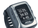
Each satellite broadcasts its position in such a way that the GPS receiver can readily determine where the satellite is and how far away the receiver is from that satellite. The data stream from any four satellites is sufficient to locate the receiver almost anywhere on Earth (latitude, longitude and altitude). Modern GPS receivers typically improve their accuracy by working with the fact that at any instant there are at least eight satellites visible overhead. While GPS can determine a position on the planet within a few meters (the Garmin Forerunner 405 I was also playing with during this review routinely reports 12m accuracy) it is notoriously unreliable for altitude. The 800 has a barometric altimeter in it to provide reliable measurement of altitude changes (if your Garmin starts reporting really odd altitude measures after a wet ride, check that the opening in the case is not clogged with muck).
Although the first GPS unit I saw in 1990 cost well over a thousand dollars and was rather large, the progress of computerisation means that GPS in 2012 is contained on one small chip that consumes relatively little power and that GPS technology is quite inexpensive now. These chips are found in most smart phones and, of course, in the Garmin 800. They are even smart enough to remember where they were when last turned off. If you turn them back on in the same place the location fix takes virtually no time at all.
Russia, the European Union, China, Japan and India all have in progress an alternative navigation system to USA’s GPS. Perhaps in a few years we will have locational information even more readily available than currently.